Friday, May 10, 2013

Site Four: The San Andreas Fault

Location California Coast: California: USA
 37°46'59.47"N   122°36'44.72"W
Tectonic Activity and Results: Frequent Earthquakes
Recent Activity: 2004 Parkfield Earthquake

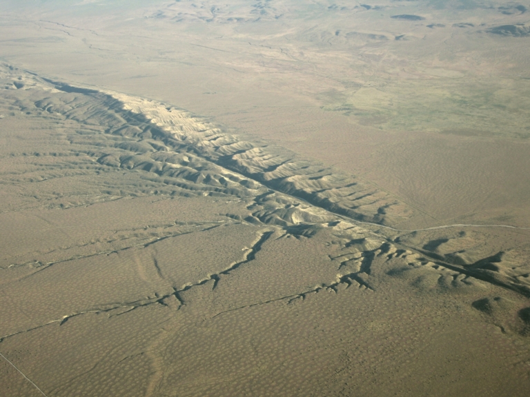
Humans are incredibly stubborn. That was my most prominent thought after seeing the fault. I will include a map of the fault, countless cities are built on the fault. And time after time, we rebuild them. But maybe its not stubbornness though, maybe its solid determination, the undying spirit of human kind. But of all places to build? The San Andreas Fault is the boundary of the Pacific and North American Plates. Two of the biggest plates on Earth bumping and grinding against each other, the Pacific Plate moving north-west and the North American Plate moving south-east (this is called a Transform Boundary). This constant collisions cause earth quakes of large magnitude and caused the 1908 San Francisco earthquake that measured 7.9 on the MMS (moment magnitude scale). So I find it funny that humans, either from stubbornness or determination keep putting themselves in the ring with Nature, but I guess we will never change, never give up, till we defeat the quakes and tremors that plague the area around San Andreas Fault.

This is my last blog post so I would like to say good bye, and I hope you had a fun time following my adventure.


Thursday, May 9, 2013

Site Three: Mount Everest: The Top of the World

Location:  Himalayas: Tibet: China
  27°59'16.43"N    86°55'30.23"E
Tectonic Activity and Results: Frequent Earthquakes, Mountains
Recent Activity: 5 cm of Elevation gain per year

Wow, the view is amazing. It was a hard, stressful, trying climb up. There were moments I though I would be stuck, times I thought I would die, but through endurance, determination, and stubbornness I made it. The weather the whole way up seemed bad to me, but the locals and the veterans said it was nothing. But heedless of the weather on the way up at the top it was clear. On the highest point of the world there rests a string of flags from every country in the world. This symbol of global unity raised my spirits and gave me more energy I would need n the way down. A little embarrassed at always having to ask explanations for the formation of the different sites I've visited i brought a book. And so at the top of the world I sat down and read a book.


Wednesday, May 8, 2013

Site Two: The Mid-Atlantic Ridge (MAR)


 Location: Off the coast of South America
   0° 3'46.83"S    24°51'57.11"W
Tectonic Activity and Results: Submarine Volcanoes and Volcanic Vents
Recent Activity: Constant Volcanic growth, Plates move 2 cm away from each other per year

My second stop was the Mid-Atlantic Ridge, sense the top of the ridge is on average 8,200 feet below sea level we traveled down in a Bathyscaphe (mini-sub. A bathyscaphe cock pit is roughly six feet in diameter and has huge floats above it full of aviation gasoline. It weighs six tons in the water due to the amounts of reinforcement and layers need to achieve huge depths. After viewing the peaks of part of the largest mountain range in the world we decided send it deeper. I also saw the amazing tube worms. Did you now they can grow to over 6 feet and live over 250 year? Its a worm!

After some time our sub descended to the bottom of the the flank. At around 24,600 feet under the sea the world seems alien. I was somewhat worried by the fact that if the sub broke I would be subjected to over 1000 atmospheres of pressure, but I was distracted by the amazing scenery I could see through the tiny porthole. At the bottom I was surprised to see some light, it was the quickly cooling magma of a volcano. This confused me at first. I knew it was a divergent plate boundary where the plates moved away from each other. So how? I asked the Alan Williams (the pilot and also a vulcanologist) why there was a mountain range formed here? He said that as the plates moved away from each other, magma seeped up and cooled forming the base of that mountain. The lave continued to seep to the top making the mountains higher, and all along the boundary this was happening forming the largest mountain range in the world. So I took lots of pictures and we headed back up. I had the weirdest feeling going back up, knowing I would never see that different world again.


Monday, May 6, 2013

Site One: Mount Saint Helens

 Location: Washington: USA
 46°12'29.00"N    122°11'44.04"W
Tectonic Activity and Results: Moderately Frequent Earthquakes, Volcanoes
Recent Activity: 1980 Eruption

Today we traveled to Mount Saint Helens. It has been almost 33 years to the day sense the volcano erupted and the forestation is still creeping slowly back. The ranger who accompanied us to the summit told us that the regrowth of the forest had been helped by the deposits of ash left behind by the eruption. When i asked him to clarify how the mountain had been formed though he was dumbfounded. So instead i turned to the leading geologist of our expedition, Warren MacMillan, a Harvard professor. He said that inland volcanoes such as Mount Saint Helens were formed when the submerged edge of the lower plate in a subduction boundary heated up and the liquid rock (at that point magma) burned its way to the surface (becoming lava). The lava eventually layered up enough to create the mountains we know today. After taking many photos. with this cleared up we drove back to Seattle where the our ship awaited.

http://volcanoes.usgs.gov/activity/methods/deformation/tilt/msh.php

Saturday, May 4, 2013

NOTE:

 This is a work of fiction. The characters and events that are said to have taken place are fiction. Any similarities to real events or persons living or deceased are accidental and were not intended by the author.

Introduction

Today is my last day in Seattle before I leave for my global photo tour. I will be touring around the earth and under the sea via the RV Endeavor. It is a research vessel (RV) equipped with a icebreaker hull, a mini sub and equipment to make observations about the physical, chemical, and biological characteristics of the waters. On land i will accompany a team of highly trained geologists, vulcanologists, and paleontologists as we seek to better understand the movement and history of our Earth's tectonic plates.

The first site I will visit is local to Washington, Mount Saint Helens, where this  active volcano erupted on May 18, 1980. This extensive mountain its an ideal spot for me to document and learn about the formation of mountains and volcano from subduction (a type of conversion zone) of tectonic plates.

Then I will travel shipboard to the Mid-Atlantic ridge (MAR) to study the divergent boundary that forms the longest mountain range on Earth. My team is currently looking for a bathyscaphe and pilot in which to dive down. If we are unable to find one I also hope to find and document some of the tube worms that live on the volcanic vents.

My next stop is the Himalayas. This mountainous range hosts Mt Everest the highest point on Earth, and K2  the tallest mountain from summit to peak. A these awe-inspiring mountains were formed by a collision boundary between the Eurasian Continent and the Indian Subcontinent. Across a two month period I will try to acclimatize myself to the low oxygen then climb to the top of the world. I plan to use a oxygen tank like most, because otherwise I doubt I could make it to advanced base camp. I'll bring back some pictures so I can share the best view in the world.

My final stop is the San Andreas Fault in California. It is on the Transform boundary of the North American Plate and the Pacific Plate. It has caused countless earth quakes and caused the Famous 1906 San Francisco fire. As always I'll take lots of picture.

I am extremely excited and hope I can capture all the amazing moments to share with you!
Wish me luck!